If you want to get to know Mallorca on Mountain bike but you are a beginner or you don’t want a complicated route with technical paths, here in this post I am going to recommend 5 easy routes around Mallorca on MTB,
And yes, I did said easy and on MTB but it will not be on the bike path, there will be dirt tracks, stones and some surprises too, but they will be relatively easy routes for all those who want to start on the MTB and want to get to know the hidden Mallorca
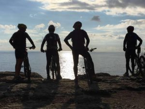
As they are easy routes and in theory, you are starting in this wonderful world of Mountain bike it’s always better if you go accompanied by a friend, always remembering to take all the necessary equipment for possible repairs, a helmet and gloves.
We also would like to take this opportunity to remind you that we offer you our guiding services where you can enjoy these routes carefree, you will be shown the most important parts of the route, be helped in long climbs and descents, as well as being recommend the best places to stop for a snack and eat a typical Mallorcan products.
The 5 best Easy MTB routes in Mallorca
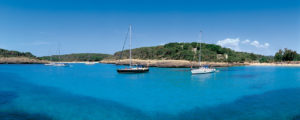
1 Cala Pi
Distance: 30km
Elevation gain: + 300m
Difficulty: easy
Approximate duration: 3-5 hours

Route through the south coast of the island where we will go along the sea practically the entire route for a varied terrain of roads, trails, some asphalt and some stretch of stone which you can walk if you find it difficult.
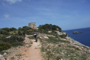
A spectacular route for its landscapes of cliffs and the sea, where you will pass through the small seaside towns of Sa Rapita, S’Estanyol and Cala Pi. We will also have the opportunity to see some of the defence towers that were used many years ago to warn one part of the island to the other when it was being attacked by the enemy. We will also discover some of the oldest estates on the island among vineyards.
We recommend you bring something to eat and drink as you may not find anything open during the route although in the mentioned places you can find bars and supermarkets but normally only in high season.
2 Porto Colom
Distance: 25km
Elevation gain: 300m +
Difficulty: easy
Approximate duration: 3-5 hours
This route covers part of the eastern side of the island along roads and trails in the San Salvador area.They will take us to one of the most important farms on the island, El Fangar, and then goes towards the sea where you will see the turquoise waters and reach one of the most natural ports large on the island, Porto Colom.
On this route we will have some ascents and descents on paths and trails without complicated technical areas. We will only find a slightly more difficult section near the sea that will help us to improve our techniques and if not, you always have the option of walking for a while.
On this route we will not find anywhere to buy food or drink so we recommend that you go well prepared.
3 Arta
Distance: 28km
Elevation gain: 600m +
Difficulty: easy
Approximate duration: 4-5 hours
Route through the northeast side of the island where by road you will reach the sea to see some of the best beaches on the island. You will pass by the Llevant Natural Park and also through the towns of Arta, Cala Ratjada, Cala Murada where you can stop to eat and drink something.
In the summer season it can get quite hot due to the lack of trees, so the best time would be from January to June or from September to December.
As there will be long stretches without passing through villages or towns, we recommend you always carry some food and drink with you.
Apart from the photogenic landscapes we also recommend that you visit the Castle of Arta
4 Tossals
Distance: 28km
Elevation Gain: 500m +
Difficulty: easy
Approximate duration: 4-5 hours
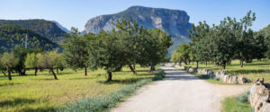
On this route you will visit the Sierra de Tramuntana where you will be able to see how spectacular it is. There is an initial ascent which is practically all asphalt following the course of a torrent where by going little by little you can slowly get through it. After on trails and roads, you will cross centuries-old olive fields between the mountains, an ancient Roman road and spectacular descending landscapes.
If you can do this route after rainfall maybe you can see water running through all the torrents.As we will not go through any town, remember to take water and snacks.
5 El Toro
Distance: 25 km
Elevation Gain: 500m +
Difficulty: easy
Approximate duration: 4-5 hours
Route through the south-west of the island that runs through an old military area and where we can see the Cala Figuera lighthouse, old trenches and bases of military machine guns. You will pass by some of the most beautiful coves in Mallorca with fantastic views and all along roads and trails where only maybe in some area you may have to walk.
We also recommend bringing water and snacks since we do not go through any village or town.